Don’t trust AI

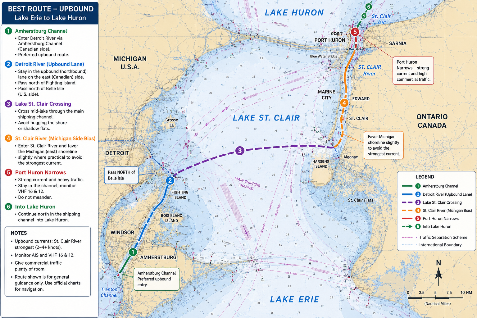
I’ll soon be bringing a sloop from the Cleveland area to Muskegon. I asked Chat GPT about the best ways to mitigate the current going up bound from Lake Erie to Huron. The directions made sense, then I asked it for a chart with the plotted directions. What a mess! See the comical chart attached.
As a side note, anyone with experience that has advice, this will be our first time. All my big lake sailing is in Michigan, northern Huron and the North Channel.
An homage and a suggestion
PermalinkThe recent discussion brings to mind:
More than just an homage:
The following is more than just an homage to the old ways of doing things. Knowing how it used to be done adds a layer of safety.
I would suggest that all skippers learn the ways of position fixing, piloting, and navigation and the use of navigation tools such as dividers, parallel rules, compass, etc. This is not at all for the sake of nostalgia, but I believe an understanding of the mechanics of navigation gives a skipper a large advantage at using safely and interpreting correctly the modern tools at our disposal.
I am particularly wary of dependence on routing tools. One thought is to do the route yourself prior to any consulting of electronic suggestions. Then compare it with the route suggested by the electronic (or personal) router. In this way, one can compare discrepancies and learn from the differences and carry with you an internal sense of the variables: invaluable when conditions change and the route must be adjusted “on the fly”.
This is particularly valuable when weather is thrown into the mix such as occurs in planning/routing multiple day passages to best take advantage (or avoid) the forecast winds.
The above can be done with coastal cruising where routing programs are used and becoming more common.
More drastic events might include one’s nav system GPS failing: a smart phone might give a latitude and longitude, but are there the skills to put it on a paper chart: is there a paper chart? Or a lightning strike zaps all electronics on board.
I would finish be suggesting that these skills are also just fun to have and use: perhaps get out the tools and plan a route as preparation for the onset of the season.
My best, Dick Stevenson, s/v Alchemy
I did the same type of thing…
PermalinkI did the same type of thing and got reasonable overnight stop suggestions. It was a series like this.
What is the current speed of the Detroit and st Claire rivers?
Give me the strongest-current sections to watch for
Can you give me the best route to take
Can you show me this on a chart
And that’s when it happened.
What I wanted was a plotted route. I think maybe I could have uploaded some proper charts first and it could have worked, but at that point I just switched to my chart plotter app.
I want more
PermalinkWhat prompt did you use to generate this? It's fascinating what kinds of alternate Earth cruising grounds it would generate. I want to know how it would tell me to plan a cruise from Meldrum Bay to Parry Sound, with detailed charts of course.
I tried the following on ChatGPT: "I am planning a sailing cruise from Meldrum Bay to Parry Sound, Ontario. Please generate an itinerary and detained charts with navigational hazards noted. "
The first sentence of the reply was: "I can help with route planning, but I cannot generate or reproduce the detailed nautical charts themselves."
Then it gave me a reasonable ten-day sailing itinerary with a list of the CHS charts required. Needless to say I was very disappointed.
So what changed?
Wow! Just wow!
PermalinkIt is hilarious but also a bit scary because there are people who would take it for cash.
I once sailed with a fellow who used Google for everything. Quote on a trip home from the marina: "No, I don't know which road we're taking, I just follow the blue line".
He discovered the autorouting function in Navionics and concluded that he would never have to read a chart again. He would love this approach.
Amy give good advise. Long…
PermalinkAmy gave good advise. Long ago I was told, "When you go north under the bridge, if you can't reach out and slap hands with the fishermen on shore you're too far out."
Hilarity ensued
Permalink…but only if you don’t follow that chart. Should be pretty easy to avoid since that canal through Ontario doesn’t exist. Not to mention the other mess.
I did a run from Lake St Clair to Georgian Bay many times. They current wasn’t ever a problem until the blue water bridge. Then you hug the Canadian shore and go full power ahead until you’ve passed it and then can start to make your way off the shoreline. When I say hug the shore, I mean like you can almost reach out and touch it. The current will be about 5kts.
That chart is an absolute…
PermalinkThat chart is an absolute hoot!
Just follow the freighters. And to mitigate the current --- If you are power, buy more gas. If you are sail, allot more time.